
Gaza between rubble and open cafés: what the images really show
Open cafés and destruction can coexist. We examine original videos, satellite data and the limits of images, without generalising.
Documentary research, not on-site reporting
In one minute
An open café is not necessarily a staged scene. But neither is it a picture of conditions throughout Gaza. The reports examined document specific businesses, while satellite analysis describes extensive damage on a different scale. The useful question is not which image to discard, but what each one demonstrates.
We have not identified a specific source to assess that literally claims every building has been destroyed. We therefore do not attribute that statement indiscriminately to the media. This investigation separates three questions: the extent of the damage, the existence of places still operating, and the conclusions that can be drawn from videos. Dates are essential: none of the archive images here is presented as footage taken today.
Frequently asked questions
Has all of Gaza been destroyed?
No, not every building has been razed. The UNOSAT assessment of imagery from 16 June 2026 classifies about 82% of structures as destroyed, damaged or possibly damaged. This is not the percentage of territory destroyed and does not measure conditions after that date. [1]
Are shops and cafés really open?
How can businesses stay open amid rubble?
Some structures remain usable and some businesses have resumed operating. Royal Café’s owner tells Reuters about generators and batteries. A working venue can therefore coexist with service interruptions and nearby destruction: being open does not mean general normality. [5]
Are people still working?
If goods are for sale, can everyone buy them?
No. Availability and affordability are different. The WFP report of 23 July 2026 describes fragile gains and families still in crisis. A clip of stocked shelves does not measure prices, incomes, how long supplies last or whether people can reach the shop. [7]
Do shop images disprove news reports showing destruction?
Not by themselves: an open business and extensive damage can both be real. Challenging an article requires checking the exact claim, date and area. Saying every building is destroyed is different from describing extensive devastation; this dossier does not judge all media indiscriminately. [3] [4] [5]
Two images, one legitimate question
One shot shows gutted buildings. Another shows people meeting in a café and ordering something. Placed side by side without dates or locations, the scenes can seem incompatible. That impression is precisely what makes the question worth investigating: how much does the camera frame tell us, and how much remains outside it?
The risk is not in looking at the second scene as well. It is in asking it to answer a question it was not designed to address. A photograph describes a selected space at a particular moment. A damage assessment attempts to describe a much larger whole. Without making that distinction clear, the visual contrast becomes a shortcut: a café table becomes evidence of normal life for an entire population, or rubble on one street becomes the disappearance of all activity.
The positions: there is no single voice called “the media”
A newsletter issued by the Israeli embassy in Australia on 6 November 2026 presents photographs of a supermarket, bakery and restaurant, credited to Israel MFA, in opposition to Hamas’s narrative. It is an original government document: it establishes that this communication was circulated. It describes the pictures as being from “this week”, but does not provide each business’s name, address and exact filming date. Those photographs therefore do not constitute an independent assessment of conditions throughout Gaza. [6]
Nor do we find only images of destruction elsewhere. Middle East Eye and Al Jazeera English have published reports on cafés and ice-cream shops; Reuters has reported on people watching the World Cup in a café. These are different outlets and materials, not a single source. Their existence is enough to reject an absolute statement such as “no media outlet shows open businesses”; it is not enough to assess the balance of international coverage as a whole. [3] [4] [5]
Assessing an allegation of distorted representation requires a headline, passage, date and context. “Gaza” can mean the city or the entire Strip; “destroyed” can be a descriptive formulation or a quantitative claim. Without knowing who said what, it would be easy to rebut a statement more extreme than the one actually made. This research has not found a specific source to assess for the literal claim that “100% of buildings have been destroyed”.
The satellite data: what “damaged” means
On 29 July 2026, UNOSAT published an assessment based on imagery from 16 June: 201,290 structures classified as affected by damage, approximately 82% of the total considered. The table distinguishes four levels. The report states that this is a preliminary analysis that has not been validated in the field. [1]
| UNOSAT category | Structures |
|---|---|
| Destroyed | 134,422 |
| Severely damaged | 13,848 |
| Moderately damaged | 28,096 |
| Possibly damaged | 24,924 |
| Total across the four categories | 201,290 |
The total is not the “destroyed” category alone. Nor does 82% measure land area, the number of homeless people or the habitability of every building. The remainder, approximately 18%, is not a certificate of safety or functionality either. The observation date must not be confused with the publication date, and neither automatically describes November. [1]
This distinction does not artificially play down the problem: it makes the language used to describe it verifiable. Before repeating a percentage, we need to know what is being counted. An apartment, a building and a structure may belong to different counts; electricity or water networks can also affect places that have not collapsed. Answering “how liveable is this place?” therefore requires more than an inventory of buildings alone.
Two different percentages are not automatically a contradiction
OCHA’s snapshot of 28 October reports 76.6% of housing units damaged or destroyed: 371,888 out of 485,361. Its stated source is the RDNA, referring to October 2025 and published in April 2026. We also opened the original report: its Housing section confirms the baseline total and the 371,888 affected homes. These are housing units, not the number of structures counted by UNOSAT. [2] [12]
Placing 76.6% and 82% side by side without explanation creates only an apparent comparison: the unit counted, period and method differ. The difference cannot automatically prove that one source is lying; nor can it establish a trend over time. A valid comparison would require consistent definitions and comparable series.
On the beach: one business, not a sample of the Strip
On 15 August 2026, Middle East Eye published a video about On the beach, a café associated with journalist Hind Khoudary and located by the report in Gaza City. Its description says it opened roughly a week earlier. We reopened the original channel and metadata and checked the report’s preview frames. We did not independently geolocate the address or verify whether it remained continuously open in subsequent months. [3]
The source has tangible but limited value: it describes one business through an identifiable report. A customer in the frame does not statistically represent people who cannot get there, cannot afford it or live elsewhere. This limitation does not make the café nonexistent: it prevents a single case from carrying the weight of a comprehensive survey.
Middle East Eye: On the beach, Gaza City — YouTube ↗
Flora and Royal Cafe: reopening does not mean a return to normal
On 29 July 2026, Al Jazeera English published a report on Flora, an ice-cream shop and café opened by Palestinian students to support their studies and families. The original and metadata are accessible; we also checked the preview frames. The economic purpose is the one described in the report, not a conclusion reached by inspecting the business’s accounts. Its exact address has not been independently verified. [4]
Reuters’ original record for footage filmed on 11 and 13 June describes the Royal Cafe in Gaza City, where people watch the World Cup. The owner discusses alternative power supplies, batteries and a generator. The same documentation includes scenes of damaged buildings and displacement. We read the shot list and the statements it contains, rather than independently verifying the entire video. The material is linked to its source, not reused as though it were free of charge. [5]
These cases suggest an essential editorial distinction: a business operating is news; a city returning to normal is a much broader assessment. Demonstrating the latter requires continuity of services, accessibility, safety, incomes and living conditions, not merely a setting that looks orderly.
Al Jazeera English: Flora, ice cream and education — YouTube ↗
Goods on shelves and the ability to buy them are different questions
In its report of 23 July 2026, WFP describes fragile improvements through aid and commercial supplies, alongside families still in crisis. The source does not claim that all trade has disappeared: it describes a setting in which goods circulating and difficulties accessing them can coexist. WFP is itself an aid operator, a circumstance to bear in mind when evaluating its accounts. [7]
A supermarket video can help document the presence of particular goods in that shop, if its date and location are established. On its own, it does not measure prices, incomes, how long stocks will last or whether people can reach it. For the same reason, a queue at a distribution point does not necessarily describe every market in the Strip.
Geography and chronology, not a collage without coordinates
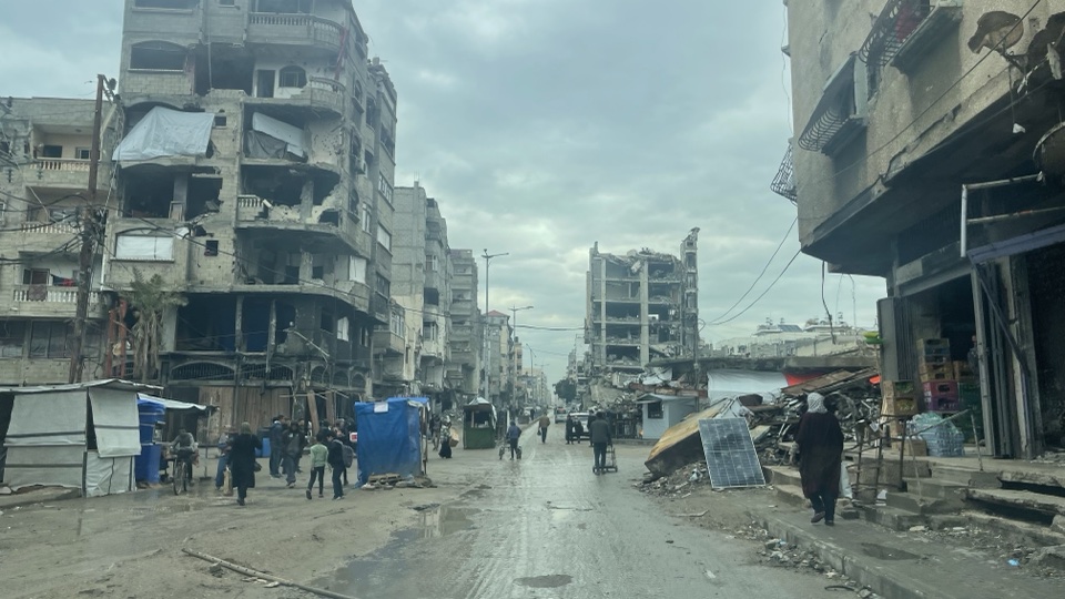
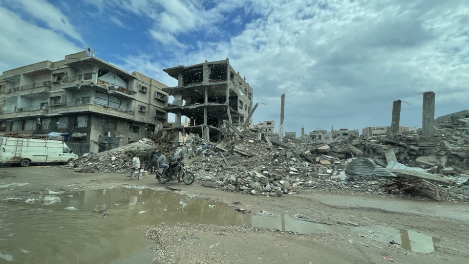
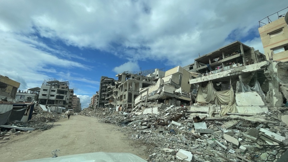
The evidence collected covers different scales and moments: street photographs from February 2025; satellite data from June 2026; reports on businesses between June and August; a government communication in November. Presenting them as though they were all recorded in the same week would create precisely the confusion that fact-checking should resolve.
| Material | Attributed location and date | Appropriate use |
|---|---|---|
| Badwan photographs | Gaza City and Khan Yunis, February 2025 | Archive record of the scenes depicted |
| Satellite analysis | The Strip, imagery from 16 June 2026 | Classification of damage to structures |
| Royal Cafe | Gaza City, 11 and 13 June 2026 | Case described by Reuters |
| Flora | Gaza, published 29 July 2026 | Case described by Al Jazeera English |
| On the beach | Gaza City, published 15 August 2026 | Case described by Middle East Eye |
We do not publish a falsely precise map with invented pins. Localities are not verified addresses, and a damage map is not a map of every open shop. The archive photographs selected here also have a limited purpose: to show authentic scenes, not to construct a “before and after” pairing with the café videos.
What is missing for a broader verdict
We do not have a complete, up-to-date census of open businesses, or a representative sample of published videos. These cases therefore cannot establish the share of businesses operating today. Nor have we systematically measured how much coverage each outlet devotes to reopenings compared with destruction. In particular, no supermarket in this sample has been independently authenticated: the three selected journalistic cases concern cafés or ice-cream shops, while the supermarket images in the newsletter remain an attributed government communication.
The research also distinguishes the authenticity of a channel from independent verification of a scene: an original report attributed to an identifiable outlet differs from an anonymous repost, but it does not automatically replace geolocation, checking the filming date and analysing editing. Social-media clips whose originals we could not verify are not part of the core evidence. A failure to verify them does not establish that they are false.
Updating this investigation would require, for example, new comparable damage data, recent and verifiable information on the businesses described, or a specific headline making a contestable quantitative claim. Any correction must state what changes and on what evidence. We will not change a verdict simply because a video is more emotionally persuasive.
The conclusion: acknowledge both realities without overstating either
The initial question was not trivial. Images of everyday life deserve space: they can reveal economic initiative, adaptation and places that continue to exist. Excluding them in advance would impoverish the account. But turning them into proof that everything else is exaggerated reproduces the same flaw in the opposite direction.
The defensible conclusion is neither “everything is normal” nor “nothing remains”. It is that the available evidence describes extensive damage while also documenting specific businesses. An investigation must preserve the scale, date and meaning of each piece of evidence. Readers can then assess the facts without being forced to choose between two images falsely presented as irreconcilable.
Putting the claims to the test
Red marks an unproven conclusion, not automatically a falsehood. Green applies only to the stated claim and scope.
The UNOSAT assessment documents extensive damage to structures.
Confirmed within the dataset · The data concerns the specified satellite classification and date, not the destruction of every building or every square metre. [1]
Open businesses prove that life in Gaza is normal.
Conclusion not demonstrated · The scenes provide neither a representative sample nor sufficient measures of safety, accessibility and continuity of services.
Read also: Gaza, genocide allegations and the court proceedings
Sources and credits
- UNOSAT, damage assessment using imagery from 16 June 2026
Published on 29 July. Original checked by the desk; preliminary classification not field-validated.
- OCHA, Gaza reported impact snapshot, 28 October 2026
Snapshot checked alongside the Housing section of the underlying original RDNA report.
- Middle East Eye, Palestinian journalist Hind Khoudary opens cafe in Gaza City
15 August 2026. Original, metadata and storyboard checked; location attributed to the report, without independent geolocation.
- Al Jazeera English, Ice cream for education: Gaza cafe raises funds for studies
29 July 2026. Original, metadata and storyboard checked; exact location not independently established.
- Reuters, Gazans displaced by war watch World Cup from the ruins
Footage from 11 and 13 June 2026. Original record and shot list read; no independent review of the entire footage. Link to source, no reuse of the video.
- Embassy of Israel in Australia, newsletter of 6 November 2026
Page 7. Government communication with commercial images credited to Israel MFA; not a representative measure of the Strip.
- WFP, Hunger in Gaza: aid delivers fragile gains, but families remain in crisis
23 July 2026. Operational source on food availability and access; the organisation also describes its own intervention.
- Jaber Jehad Badwan, street in Gaza City, 23 February 2025
Archive photograph, unchanged file. VRT permission and CC BY-SA 4.0 licence checked; it does not describe conditions in November 2026.
- Creative Commons Attribution–ShareAlike 4.0 licence
Attribution, licence link and indication of changes; share alike in the event of adaptation.
- Jaber Jehad Badwan, Khan Yunis, 20 February 2025
Archive photograph, unchanged file, CC BY-SA 4.0. Not a before-and-after comparison with the businesses in the videos.
- Jaber Jehad Badwan, Sheikh Radwan, Gaza City, 22 February 2025
Archive photograph, unchanged file, CC BY-SA 4.0. Documents the specified scene and moment, not every street in the city.
- World Bank, European Union and UN, Gaza RDNA, April 2026
Original opened and extracted: Housing section, printed page 22. Confirms 485,361 baseline units and 371,888 affected. No photographs or graphics from the report are republished.


